ONLINE FORMAT
| Image | 37 |
| Text | 15 |
| Folder | 1 |
THEME/PROJECT
| North Carolina Maps | |
| Daily Reflector Images | 10 |
| Military History | 5 |
| Military History: Marines | 5 |
| Transportation | 4 |
| Agriculture | 2 |
| Early American History | 2 |
| More |
DIVISION
| East Carolina Manuscript Collection |
Search Results
53 results found for:
collection:North Carolina Politics
View all North Carolina Maps material.
Currently viewing items 1 - 40
| Next |


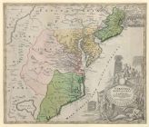
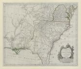
![A new and correct map of the province of North Carolina drawn from the original of Colo. Mosely's [i.e. Moseley's]](https://digital.lib.ecu.edu/encore\ncgre000\00000005\00004542\00004542.jpg)


Currently viewing items 1 - 40
| Next |